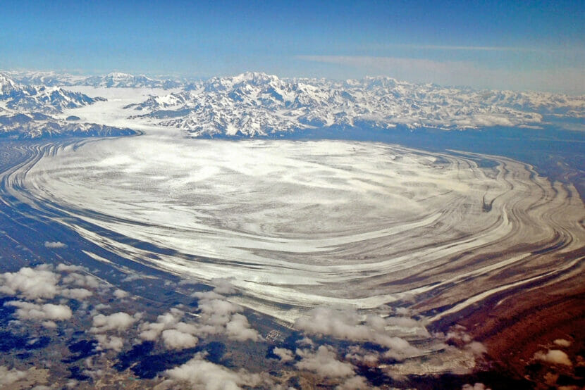
Alaska is the home of the world’s biggest piedmont glacier — meaning it falls from a mountain into a plain. But a new study has revealed it is not quite as big as previously believed, and its low-elevation positioning makes it more highly susceptible to melting that would affect the rise in global sea levels.
The findings are in a study of Malaspina Glacier, which spills out of the St. Elias Mountains into a wide circular lobe atop a broad plain that stops short of the sea.
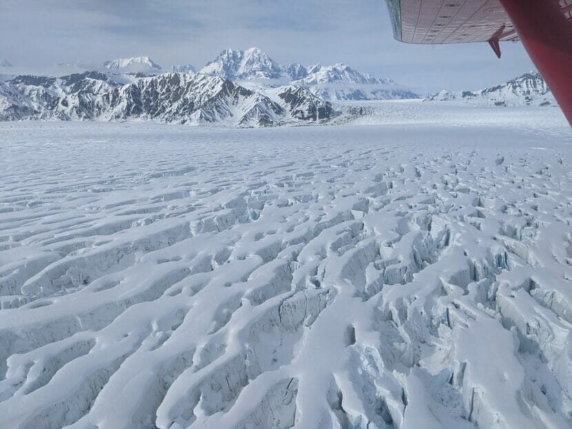
The study, led by University of Arizona scientists and published in the Journal of Geophysical Research, used specially designed radar devices to conduct what was, in effect, a full-body scan that penetrated down to Malaspina’s base, including into the bedrock underlying it.
It found that Malaspina’ s ice volume is about 690 cubic kilometers, about 30% smaller than prior size estimates. Two-thirds of the glacier is grounded below sea level, and those bottom portions of the glacier are undercut by several channels running as deep as 350 meters below sea level, the study found. At the same time, the land barrier that separates Malaspina from the ocean is shrinking as lagoons on it expand. Earlier research by the National Park Service, University of Arizona and UAF indicates that saltwater is already encroaching through that dwindling land barrier and that Malaspina may be transitioning into what is known as a tidewater glacier.
If Malaspina’s 590 cubic kilometers of above-sea-level ice melts, that would raise global sea levels by 1.4 millimeters, about seven times the current annual impact on sea levels by Alaska glaciers’ melt, the study found.
Exactly when and how fast Malaspina will melt out is a subject still being calculated, said the study’s lead author, Brandon Tober, a University of Arizona geophysics doctoral student. That work is being done by the same team that produced the new study, with members from UAF and the University of Montana as well as Tober and his University of Arizona colleagues. Tober said he hopes some results that forecast Malaspina’s future will be ready for release by the end of the year.
The Malaspina-scanning research was part of NASA’s Operation IceBridge, a program that ran from 2009 to 2021 and used airborne equipment to measure sea ice, glaciers and ice caps in both polar regions.
Generally, glacier volume measurements are made through calculations from afar that factor in the physics of locations and movement over time. But those calculations are just estimates, Tober said.
“Really, the main way to figure it out is to go fly over them with radar and measure,” he said.
A challenge to radar measurements of Alaska glaciers is that in this temperate latitude, the ice is considered warm, which means it holds pools and pockets of water. That liquid water often absorbs the radio waves used by radar, interfering with any measurement attempts. To address that problem, this Malaspina project used extremely low-frequency waves that were able to penetrate those sections of liquid water, Tober said. Most of the data for the study came from flights done in 2021, completing a grid pattern over the glacier, but there is use of data collected as far back as 2013, he said.
Malaspina, located mostly in Wrangell-St. Elias National Park and Preserve, has a size and configuration that makes it a good site for such measurements, Tober said. “It’s this big lobe of ice on a broad plain,” he said. Smaller glaciers that wedged more tightly in mountainous spaces are less suitable for such radar analysis because the signals can become distorted in complex topography, he said.
Alaska holds much less than 1% of the world’s glacial ice, but Alaska glaciers are outsized contributors to global sea-level rise, which is largely the product of meltwater from land ice, including both glacier and dice sheets, and thermal expansion as the oceans get warmer and their waters take up more space.
Alaska glaciers contribute more than any other source of land ice aside from the Greenland and Antarctic ice sheets, according to various recent studies that put Alaska glaciers’ contributions at around 6% or 7%.
From 2000 to 2019, about 21% of sea-level rise is from the world’s glaciers – not counting the Greenland and Antarctic sheets — and of that, about 30% was from melt of Alaska glaciers, according to a 2021 study published in the journal Nature.
This story originally appeared in the Alaska Beacon and is republished here with permission.